

Binn Doire Chlair [Derryclare]
Good walks are even better shared.
L8151 : Summit cairn on Derryclare
Colin Park Photo source
Overview
Binn Doire Chlair (Derryclare)
Overview
Binn Doire Chlair, affectionately known as Derryclare, is one of Connemara's hidden gems. With an elevation of 518 meters, it may not be the highest in the area, but what it lacks in height, it makes up for in astounding views and rugged terrain. Whether you're an experienced hiker or just looking for a lovely day out with a stunning backdrop, this mountain offers something for everyone.
Geology
The mountain consists predominantly of granite, which has stood the test of time against the elements. Look around, and you might spot unique limestone outcrops—perfect fodder for a geology enthusiast seeking Instagram gold!
The Route
The Derryclare Lough Loop is a popular starting point that provides a solid four to five hours of hiking joy. Starting from the Derryclare Lough car park, this route is a moderate challenge, featuring mostly well-trodden paths, rocky outcrops, and perhaps a few boggy bits to keep you on your toes. Watch where you step; you don’t want to end up with muddy boots!
Summit Features
At the summit, you'll be greeted with a small cairn that marks the peak—an ideal spot for that celebratory selfie with panoramic views of the Twelve Bens and Derryclare Lough below.
Views
Expect jaw-dropping sights of Connemara’s wild beauty from the top. On a clear day, the vistas extend for miles, revealing shimmering lakes and rugged peaks that whisper tales of adventurers past. Spring and early autumn are particularly good times for visibility, so time your visit right!
Hazards
Expect some boggy patches, so wear appropriate footwear unless you fancy a dip in some cold Connemara mud! Also, weather can change swiftly, almost as unpredictable as your hiking partners’ choice of trail snacks.
Nearby Summits
There are more peaks to conquer nearby, including Bencorr Mountain (711m) and Benbaun (729m). Plan a multi-peak day if you’re feeling adventurous!
Getting There
The nearest parking is at Derryclare Lough car park, offering ample space and scenic views before you even step foot on the trail. Public transport options exist but may require a taxi for ultimate convenience. The nearest town, Roundstone, is a mere 15 km away and offers lovely cafes to replenish your energy post-hike.
History
The intriguing name Binn Doire Chlair means ‘Hill of the Oak Grove’, reflecting the verdant landscape surrounding the area. As you wander, embrace the local folklore that occupies this land; ancient tales will surely enhance your hike.
Conclusion
Binn Doire Chlair is a stunning representation of Connemara’s rugged beauty, bundled up in a moderate hiking challenge. When you do eventually reach the summit, take a moment to soak in your surroundings and reflect on how far you’ve come—both literally and metaphorically! Happy hiking!
Explore routes near Binn Doire Chlair [Derryclare]
Walks starting near this hill. Open a route to check its map, distance and full itinerary.
Route planning notes
These notes describe possible approaches. Check a route's map and access information when planning your walk.
Derryclare Lough Loop
A popular circular route starting from the Derryclare Lough car park that offers stunning vistas of the surrounding landscape.
Make a day of it, together
Find someone to share the walk with, or organise a day out along a route you like.
Photo Gallery
View all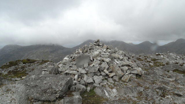 Photo could not load
L8151 : Summit cairn on Derryclare
Colin Park
Hill facts and local notes
Classifications
Elevation
675m
2,215 ft
Prominence
124m
Coordinates
53.4959, -9.7863
L815510
OS Map
37
At the Summit
A prominent rocky outcrop with a small cairn marking the highest point, offering a true sense of achievement.
Terrain & Geology
Primarily composed of granite with some limestone sections, revealing fascinating geological formations.
Views & Scenery
Breathtaking views of the Twelve Bens, Derryclare Lough, and the expansive Connemara landscape, perfect for those Instagram moments.
History & Heritage
Name Origin
The name Binn Doire Chlair translates to ‘Hill of the Oak Grove’, indicative of the lush greenery in the region.
Historical Significance
The area is steeped in local folklore, with tales of ancient monasteries and legendary warriors that add a mystical charm to your hike.
Getting There & Facilities
Parking
Derryclare Lough car park (L825537), with space for several cars and stunning views right from your parked spot.
Public Transport
Bus services are available from Galway City to Clifden; however, a taxi or private transport is recommended for easier access to the trailhead.
Nearby Facilities
Cafes and local shops can be found in nearby Roundstone, but facilities on the mountain are non-existent, so pack your lunch!
Safety Information
Known Hazards
- Boggy ground in places can make footing tricky; be careful to avoid any waterlogged missteps.
General Safety Tips
- Check weather conditions before setting out
- Carry appropriate clothing and equipment
- Let someone know your planned route
- Take a map, compass, and GPS device
- Carry emergency supplies: food, water, first aid kit, torch
Hills
Some common questions about the hills answered
Are there group walks up Binn Doire Chlair [Derryclare]?
Many walkers use Walkmates to join or organise walks with others. You can check for group walks around Binn Doire Chlair [Derryclare] through the maps
Are there other walkers around Binn Doire Chlair [Derryclare]?
Activity varies by location and time, but Walkmates lets you see whether others have shared walks or shown interest in this area. Find other people through the walking friends search walking friends for Binn Doire Chlair [Derryclare] search or of course create your own walk for Binn Doire Chlair [Derryclare]
Can I organise a walk to Binn Doire Chlair [Derryclare]?
Yes. If there aren’t any walks listed already, you can create a walk and make it available for others to join.
If you're signed up to Walkmates, you can create a walk to Binn Doire Chlair [Derryclare].
How do I find a walk up this hill?
There are often multiple ways to walk this hill, depending on experience and route preference. Walkmates helps you explore walks and routes that others have shared.
Can I suggest a new route up Binn Doire Chlair [Derryclare]?
Yes. You can suggest or create routes to share with others. Walkmates focuses on the social side of walking, so routes are used to help people organise walks and explore areas together, rather than as detailed navigation tools or route libraries.
Other uses really appreciate knowledgeable walkers sharing their routes. Share your favourite route to Binn Doire Chlair [Derryclare] here
The is an error or something incorrect about this hill. How do I let you know?
We always strive to keep the information on Walkmates as accurate as possible. If you find an error, please let us know through the contact form and we'll aim to correct it as quickly as possible
Community Discussion
Comments
Location
![Binn Doire Chlair [Derryclare] location map](https://cdn.walkmates.com/hill-maps/hill-sources/20126/53.49585_-9.78633.png)
Grid reference: L815510
View on OpenStreetMapOpens a map in a new tab, centred on the hill.
No comments yet. Be the first.